


Key Takeaways to Keep in Mind
- The great migration in Tanzania follows a fairly predictable route through the Serengeti National Park – about 800 miles every year, with over 1.5 million wildebeest on the move
- The great wildebeest migration map is an essential tool for planning your safari, helping you understand the migration’s route, timing, and key locations across the Serengeti and Maasai Mara.
- Migration maps show you the different parts of the migration – such as the Ndutu plains (January – March for the calving), the Grumeti River (May-June for the river crossings), and the Northern Serengeti (July-October for the Mara River crossings) in both Kenya and Tanzania, highlighting the multi-country aspect of the journey.
- By combining weather forecasts, satellite tracking data and rangers’ on-the-ground reports, migration movement experts can pin-point wildebeest locations with 80% accuracy
- You can plan a safari around the great big river crossings – the Grumeti River (May-June) and the Mara River (July-October) – which are triggered by rain and the availability of grazing
- With careful planning, you can pick where and when to go for the calving season, the river crossings, or the hunting grounds – all dependent on your taste in wildlife viewing
- To get the most out of your dream safari, understand the migration maps, the timing and the best places to be. It’s the only way to experience the most epic wildlife encounters
Every single year, over 1.5 million wildebeest embark on a truly epic 800-mile journey across Tanzania’s Serengeti. What you see is one of the world’s most incredible wildlife events – the great migration. The route the wildebeest take, shown on the great migration map, looks complicated, but actually makes a lot of sense. This is why it has caught the imagination of both safari-goers and researchers for decades. To be honest, working out this migration pattern with the help of detailed mapping and modern tracking tech makes a simple safari into a brilliant wildlife adventure.
This wildebeest migration is a lot more than just wildebeest moseying around – it’s a really clever natural system powered by rainfall, grass quality and predator-prey dynamics right across East Africa. Modern tracking combines sat data, GPS, along with local knowledge to predict wildebeest locations with remarkable accuracy, giving travelers the unique chance to witness different stages of this incredible journey.

Getting to Grips with the Great Migration Map of Tanzania
The wildebeest migration is a big loop – covering around 12,000 square miles across the Serengeti-Mara area. This vast land mass includes Tanzania’s Serengeti National Park, the Ngorongoro Conservation area and even spills into Kenya’s Maasai Mara National Reserve. This entire region forms the Serengeti Mara ecosystem, a critical wildlife corridor that supports the annual migration. It makes the great wildebeest migration a fantastic experience to see in 2 or even 3 countries. The great wildebeest migration map shows that the migration is a clockwise movement, triggered by the need to follow the rain and reach fresh pasture, which is a vast area of open plains.
The great wildebeest migration map points to some key landmarks like the southern Serengeti and the Ngorongoro Conservation Area, which serve as the main calving grounds. The nearby Ngorongoro Crater, formed by volcanic activity millions of years ago, contributes to the nutrient-rich soils that support lush grasses—perfect for the wildebeest to feed and have their babies. The central Serengeti is a kind of middle ground with rivers that stay full of water all year round. Meanwhile, the northern Serengeti and the western corridor are all dry-season grazing for the wildebeest, and they’re also where the river crossings happen. It’s in Kenya’s Maasai Mara that you can see the vast herds of wildebeest crossing the Mara river and the calving season—both these are major highlights for safari-goers.
Satellite tracking technology has revolutionized how we think about migration, with over 1,000 wildebeest GPS collars giving us real-time locational data. And that reveals that, while the main migration route is pretty consistent, there are all sorts of micro-movements happening all the time, like responding to local rains, being chased by predators, or having to deal with human activity. When you put all this together – topography, water sources, seasonal grazing areas – you get a really comprehensive great wildebeest migration map, which guides not just conservation efforts, but also helps plan your actual safari.
Tanzania’s Serengeti and Kenya’s Maasai Mara ecosystem lets it happen thanks to all the different land types – short grass plains in the south which give optimal nutrition in the rainy season, taller grasslands in the north which give the wildebeest food when it’s dry. The Serengeti and Maasai Mara have a gazillion water sources – rivers that never run dry, pools that form in the rainy season, and spots where wildebeest can find a drink. The Serengeti and Maasai Mara are world-class national parks, perfect for a safari – recognised as the best places on the planet to see the migration and get a taste of the incredible wildlife.
Working Out Where the Wildebeest Will Be Next
Today, modern tracking combines all sorts of systems to create really accurate prediction models. It takes in rainfall data to predict where the wildebeest will go for the best grazing. Weather forecast models can even predict rainstorms approaching – so safari operators know where to find the wildebeest days in advance.Radio collars on lead animals are the backbone of getting real-time migration intelligence. Scientists are using GPS collars to track the locations of these animals every few hours. This creates incredibly detailed movement patterns that help predict when herds will be in a particular area. What they’ve learned so far is pretty surprising – a million wildebeests don’t all march together in a big group. Instead, they move in smaller groups that come and go based on local conditions. In fact, the behaviour of one wildebeest can make a big difference to the movement of those around it because these animals are often on their own or loosely grouped together rather than being part of a big herd. This makes the individual actions of wildebeests play a pretty big role in shaping how the whole migration works.
The local ranger network is also a key part of getting accurate migration information. Tanzanian park rangers and community scouts are giving daily updates on the position of herds during the peak migration months. They’re combining old-fashioned local knowledge with modern tech, and it’s creating a more complete picture of what’s going on. This ground-truth info is helping to validate what the satelites are saying, and it’s giving us a much better understanding of how these animals behave.
Technological Tools for Migration Tracking
These days there are some seriously advanced tracking tools that are helping safari operators and tourists stay up to-date with the latest migration information. They’re using drones to monitor key crossing points and concentration areas, giving them a visual report of what’s happening with the herds.
Weather radar integration has been a game-changer for predicting when herds are going to move. By looking at the weather patterns, they can work out where the big herds are likely to go for fresh grazing. Maasai villages along the migration route are also involved in this – they’re using their local knowledge to help the tech systems. It’s creating a really comprehensive system for gathering information.
Satellite imagery helps them work out where the herds are likely to be in a few weeks time, based on things like how green the grass is and where the water is. And the good news is that this has been able to predict the general location of the herds with pretty good accuracy – around 80% of the time. Of course, the timing of the movements still depends on things like the weather and the presence of predators.
Tanzania’s Migration Micro-Regions: Detailed Mapping
The bit of the migration route that goes through Tanzania is made up of different micro-regions, each of which has its own role in the annual cycle. The southern Serengeti region is a real hotspot – it’s got three key areas: the Ndutu plains, which is the main place the wildebeests have their babies, the Salei plains which also has lots of new calves, and the Kusini area, which provides a bit of a resting stop for the herds. And it’s all got this great volcanic soil that makes it perfect for the calves to get growing.
In the central part of the Serengeti, you’ve got the Seronera valley, Moru Kopjes and Simba Kopjes – these are all areas with water available all year round, which is pretty unusual in this part of the world. These areas are all critical because they’re where the herds can rest while making their way north or south.
The western corridor is probably the most dramatic bit of the migration route. Here you’ve got the Grumeti Game Reserve, the Kerawira area, and these seasonal pools that create bottlenecks for the herds when they try to cross. The western Serengeti is where the herds tend to concentrate before they try to cross the Grumeti River.
In the northern part of the Serengeti, you’ve got the Kogatende region, the Lamai wedge, and the Mara River crossing points – these are all key areas for the wildebeest. There are lots of predators around here, and you get some of the most dramatic crossings during the annual migration. The border transition zones, such as the Loliondo area and the Ikorongo game-controlled area, are critical because they maintain the migration route. As the herds move northward, they seek fresh grazing and water sources, which drives their seasonal migration between regions.
The eastern edge of the Serengeti is especially interesting in November, because that’s when the big herds come through on their way south. At this time, the short rains begin, influencing the migration patterns as the wildebeest follow the new growth. It’s really important for the whole migration cycle.
Ndutu Region: The Calving Epicenter
The Ndutu region is like a maternity ward for wildebeests in February, when they’re all having their babies. You get about 8,000 new calves born every day during this period. And it’s because of the volcanic soil in this area, which creates this lovely calcium-rich grass that’s perfect for the mums to feed their young. Guests can actually get up close and personal with the newborns. During the calving season, baby wildebeests can be seen taking their first steps within minutes of birth, while their mothers remain vigilant, fiercely protecting them from predators.
And of course, with all these new calves around, the predators are just going wild. They’re tracking the calves, and it’s a real spectacle for visitors who are trying to see predators and prey in action.
Grumeti River System: Western Corridor Crossings
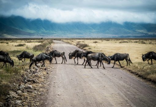
The Grumeti River is a bottleneck for the wildebeests – it’s got 15 main crossing points over a 100km stretch. This area is considered a major crossing during the migration, making it one of the most significant and dramatic stages of the journey. Each crossing is different, with its own challenges and viewing opportunities. And of course, there’s the added bonus of all these crocodiles hanging around – they’re estimated to be around 3,000 strong. These reptiles are completely dependent on wildebeests for food, and it’s incredible to see them just waiting for the herd to arrive.
But of course, this is a high-risk time for the wildebeests, and they need to be able to cross safely. There are some alternative routes they can take, but it really depends on the water levels and the number of predators around.
River Crossing Prediction: Timing and Location Analysis
River crossing predictions – at the top of the migration intelligence food chain – combine multiple data sources to forecast these wildlife spectacles to come. Grumeti River crossing predictions rely heavily on water levels and on how fast the grass is being eaten down south of the river. When southern grazing gets too scarce, and northern areas are looking a bit greener after some recent rainfall, the herds start concentrating near the traditional crossing points they’ve used for so long.
Mara River Crossing Forecasting uses rainfall data from both the Tanzanian and Kenyan watersheds. The Mara River is heavily influenced by rainfall in the Mau forest and the surrounding highlands, making cross-border weather monitoring essential for accurate predictions. Patterns and timing variations can be seen in historical crossing data from 1995 to 2024 – though all these changes in the climate have introduced new variables that forecasters have to take into account.
Early warning systems now give safari operators a 5-7 day head’s up about major crossings – though actually predicting the exact timing is tough. Herds will sometimes approach the crossing points and then pull back several times before things actually line up right. The impact of El Nino and La Nina weather patterns has a big effect on how accurate the timing can be – with some years the crossings are delayed or brought forward by several weeks compared to the norm.
Mara River Crossing Intelligence
The Mara River has five main crossing points, each mapped with accessibility and safety ratings for wildlife viewing. Crossing the Mara River is one of the most treacherous parts of the migration – with steep riverbanks, strong currents, and a population of crocodiles that think of crossing animals as their next meal. Migration camps near these crossings offer the best views of the drama as huge herds try to cross.
The tide and current analysis affects how successful the crossing attempts are – with calmer water conditions encouraging more herds to try it. Multiple crossing phenomena show up when herds cross back and forth over several weeks, as they react to changing conditions on both sides of the river. Weather dependents – things like temperature, wind and storms – can halt crossing attempts for days or weeks.
River crossings are some of the most amazing but heartbreaking moments of the migration. Young calves get tangled in the swift currents while their mothers call out from the other side in a panic. Crocodiles take their positions at the traditional crossing points – taking advantage of the chaos and exhaustion of these massive movements.
A Month-by-Month Guide to the Tanzania Migration
Understanding the annual migration requires a solid grasp of seasonal patterns and the whereabouts of the herds throughout the year. This breakdown of the annual migration focuses on the movements that happen within Tanzania’s borders – providing the essential timing information for planning safaris and tracking wildlife viewing opportunities.
January-March: Southern Serengeti Calving Season In early January, large herds start gathering in the Ndutu plains and southern regions for what’s known as the calving season. It’s around February that the wildebeest calving peaks, with the short grass plains really playing to their advantage as an ideal spot to raise the young calves. The Ngorongoro Crater’s still open and accessible during this period, offering more chances to catch some really great wildlife views.
April-May: Northward Movement Starts As the long rains begin, herds start to make a gradual move north from the southern plains. In May, the western corridor migration kicks off as the herds make their way towards the Grumeti River system. This time of year is another great opportunity to see the migration in action as animals respond to changing rainfall patterns.
June-July: Western Corridor and Grumeti Crossings By mid-July the Grumeti River is usually at its peak in terms of activity, with some real drama as the animals make their way across – and that makes for some really spectacular viewing. The western part of the Serengeti’s the main focus at this point as the herds all congregate before making the river crossing. This time of year requires a bit of flexibility in planning as the timing of the crossings can vary quite a lot.
August-October: Northern Serengeti Focus The northern Tanzania region’s where the largest concentrations of herds are to be found during this period, with regular border crossings into Kenya’s Maasai Mara. It’s the Mara River crossings that are the main event here, offering some of the most dramatic moments of the entire migration. Herds will often cross multiple times between the two countries, in response to the availability of grass and the threat of predators – visiting Kenya during this time can be a great way to see these dramatic river crossings, often with the added bonus of easier access, different park fee structures, and fewer crowds than in the Serengeti, making Kenya a pretty unique and convenient option for experiencing the migration.
November-December: Southern Return As the short rains start in November, the herds start making their way back down to their calving grounds. This is the time when the animals start to scatter out as they respond to the early precipitation in the southern regions. December sees the pregnant females start to get ready for the upcoming calving season, seeking out the best possible birthing locations.
Peak Season Mapping (July-October)
The northern Serengeti Safari concentration areas are pinpointed with GPS coordinates, which are used by safari operators to get in the best position for optimal viewing. The border crossings between Tanzania and Kenya offer the chance for multi-country safari experiences – though, of course, you need to do your research and get the right documentation in place.
Maps of tourist density during peak season really show just how packed things get around the popular viewing areas, so it’s essential to get an early-morning start and consider alternative locations if you want to get the best out of your experience. Looking at the weather patterns during this time of year, you’re usually looking at clear skies and pretty good visibility – but don’t forget that the afternoons can see some pretty intense thunderstorms rolling in, which can make the road conditions pretty tricky and affect how the animals behave.
Calving Season Mapping (January-March)
The distribution patterns in the Ndutu and Southern Serengeti really show just how concentrated the wildlife is during the calving periods. Daily movement predictions within the calving grounds give visitors a better chance of seeing the calving process and early predator-prey interactions. The fertile plains in these regions really support the highest wildlife concentrations of the whole year.
If you’re interested in predator territory overlays, you’ll see that there are certain areas where newborns are particularly at risk of attack. The road conditions during the rainy season can be pretty challenging, with some areas requiring specialist vehicles or alternative modes of transport to get by. Mobile camps during this period give you the flexibility to follow the daily movements within the calving areas.
Choosing Your Great Migration Experience in Tanzania
Choosing the right migration experience really depends on matching the migration phases to your personal preferences and interests. If you’re looking for intimate wildlife observations and high predator activity, then calving season might be the way to go – but you do need to be okay with the fact that the conditions can get pretty muddy during the rainy season. River crossings provide a really dramatic spectacle – but it does require a bit of flexibility as the timing can vary and you may need to wait around for the right moment.
Budget considerations do vary a lot between the different migration regions and seasons. Peak season pricing (July-October) is usually a pretty high premium as it’s the most in demand, and it’s the river crossing times that make it so special. Calving season (January-March) on the other hand often offers a bit of a better value, with lower tourist density and some really unique wildlife experiences – although you do need to keep in mind that accommodation options may be a bit more limited.
Accommodation options range from luxury permanent lodges to mobile camps that follow the migration movements. Permanent lodges offer a consistent level of comfort, but may require a bit of travel to get to the active migration areas. Migration camps do give you the chance to be right next to the wildlife action – but it does mean sacrificing some of the creature comforts for the location.
Calving Season Experience Selection
Ndutu mobile camps really offer the ultimate calving season experience, with guests able to walk right to the birthing areas and predator encounters – it’s a really immersive experience. Permanent lodges in the central Serengeti provide a nice base for day trips to the calving grounds – although this does require a bit of a longer travel time during peak activity periods.
If you’re visiting during calving season, it’s really worth getting out early in the morning for a game drive as that’s when the predator action is at its peak. Weather-wise, you do need to be prepared for some pretty heavy thunderstorms in the afternoons, which can make some of the road conditions tricky – and during the first part of the season, the roads can get a bit muddy too. If you’re bringing the kids along, you’ll need to make sure you’re prepared for potentially intense predator-prey interactions – and that’s not always going to be the best thing for younger kids.
River Crossing Experience Planning
One thing you really can’t stress enough is the need for flexibility when it comes to river crossings. Herds may approach the crossing points a few times before conditions are right, so you need to be prepared to stick it out for a bit and adjust your plans accordingly. Visitors who really want to see these river crossings should be prepared to adopt some multi-day strategies and keep their itineraries pretty flexible – that way you can increase your chances of seeing the action. Alternative activities during downtime include taking cultural visits to Maasai villages, going for a walk in non-migration areas, and just exploring those weird rock formations known as kopjes. And as for photography, be sure to bring a good telephoto lens to get shots from a distance when you’re observing the wildebeest river crossings, and maybe some waterproof gear for when you’re around rivers.
Accommodation Options for Migration Safaris
When planning your wildebeest migration safari – you know, that epic event in the Serengeti – your choice of lodging really makes all the difference in how up close you get to the wildlife and how much excitement you get out of it. You’ve got a whole range of options spread across the Serengeti-Masai Mara area each catering to different sorts of travel styles and budgets and which phase of the migration you want to see.
Those Mobile Migration Camps are pretty popular among the more seasoned safari-goers who want to be right in the thick of the action. These camps are set up to move with the herds, they get set up in different places to follow the migration routes across the south Serengeti, middle Serengeti, then over to the western corridor and up to the north Serengeti near the Mara River. It’s pretty cool to wake up to the sound of thousands of wildebeest rumbling through – and you’ve got a front row seat to some pretty wild moments like river crossings or calving season, depending on when you go. Things are a bit more basic in these camps than the luxury lodges but the experience is hard to beat – I mean, you’re right there among the action.
Permanent Lodges and Tented Camps offer a bit more comfort and stability – en-suite bathrooms, gourmet meals, some even have swimming pools – these places are strategically located in all the key migration zones like the middle Serengeti for year-round wildlife, the western corridor for the Grumeti river crossings and over in the northern Serengeti or Masai Mara for those famous Mara river crossings. The thing is you might have to drive out to meet the herds if the move somewhere else, but these lodges are like a luxurious base to come back to after a long day of exploring.
Basic Camping is an option for those who just want to rough it a bit and see the migration on the cheap. You can stay at public campsites inside the Serengeti National Park or the Masai Mara Reserve – it’s all about being completely immersed in the wild, and the sounds of the migration echoing across the savannah at night will leave you feeling pretty small. It’s not for everyone, but if you don’t mind roughing it a bit and want to really feel like you’re in the middle of nowhere, this is the way to go.
Location is everything when it comes to choosing where to stay. If you want to see the calving season (that’s jan-feb) look for camps in the south Serengeti and the Ndutu plains. But if you want to see the river crossings, you’ll want to be in a mobile camp or lodge near the Grumeti river (may-june) or over in the north Serengeti and Masai Mara (july-october). The migration moves with the rain and the grass, so flexibility is key—and make sure to be prepared for all eventualities when packing for your safari.

You should really book way in advance if you want to see the right part of the migration. And if you’re planning to do a serious migration safari, work with a good safari company that really knows their stuff. They’ll help you pick out just the right migration camp or lodge so you can get the most out of your time in the Serengeti-Masai Mara ecosystem.
Whether you go for a mobile camp, a luxury lodge or just a basic campsite, picking a place that moves with the migration makes for a truly unforgettable safari trip and some of the best seats in the house for one of nature’s most epic displays.
Frequently Asked Questions
How good are migration predictions, and what causes the variations from the planned routes?
Migration predictions are usually pretty accurate, getting about 80% right for general herd locations, give or take a week or so. But exact timing can be a bit tricky as all the local weather patterns, predators and people can really throw a wrench in the works.
Can I see river crossings if I visit Tanzania at the wrong time of year?
River crossings are pretty seasonal, primarily happening in June-July (Grumeti) and July-October (Mara River). If you visit outside these times, you’re probably going to miss the big river crossings, but you might still get to see some other phases of the migration, like calving season in January-February or just general herds on the move. There might be some smaller river crossings happening at other times, but those epic mass river crossings are pretty limited to specific seasonal windows.
What is the difference between staying in mobile camps that move with the migration versus just staying in a fixed lodge?
Mobile camps get you right into the heart of the migration, you can get close to the action and are flexible enough to follow the herd movements – but things are a bit more basic and you have to be willing to move around a lot. Fixed lodges, on the other hand, are pretty comfy, have all the amenities you need, but you might have to drive out to meet the herds if they move somewhere else, and you might not be able to adapt as easily to changes in the migration.
How does the weather and climate change impact the reliability of historical migration maps?
It’s pretty tricky to predict just how the migration will play out in future, because of all the local weather factors and changes to the climate – but basically some areas are getting more rain and the herds are moving in response. Climate change is messing with rainfall patterns, and that in turn is causing a precedent-shattering shift in when animals migrate each year.
In the very worst weather years, we can expect the migration timing to get knocked off by anything up to 4 weeks when compared to where it used to be. And to make matters worse – the famous El Niño & La Niña climate events are also playing havoc with traditional migration routes. Plus, the long-term climate trends are whispering that they’ll alter the timing & routes of future migrations, & that means the historical data we rely on to predict the future is going to become increasingly unreliable.
What gadgets do safari guides use to track the great migrations in real-time?
Safari guides are pretty tech-savvy and they use all sorts of fancy kit to keep track of where the herds are. That includes GPS tracking collars on the animals, remote monitoring of rainfall patterns from up in space, the latest weather prediction models and lots of info shared between rangers, all of which helps them pinpoint where the migration is headed. Plus, they’ve got the likes of HerdTracker on their mobile phones (that one’s a bit like a live feed of where all the animals are at), and also – camera drones buzzing overhead and local people from the villages out on the ground are all helping to give that extra bit of human insight into just what’s really going on.


